Datei:Japan trench topographic.png

Größe dieser Vorschau: 600 × 600 Pixel. Weitere Auflösungen: 240 × 240 Pixel | 480 × 480 Pixel.
Originaldatei (800 × 800 Pixel, Dateigröße: 221 KB, MIME-Typ: image/png)
Beschreibung
| Beschreibung |
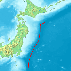
English: Map of northeastern Japan (main islands Honshu and Hokkaido) and the sourrounding seas. The red line marks the course of the axis of the Japan Trench, a deep sea trench off the east coast of Japan, which is a bathymetric expression of the subduction of the Pacific Plate beneath the Eurasian Plate. Its northern extension ist the Kuril Trench.
Deutsch: Karte des nordöstlichen Teils Japans (Hauptinseln Honshu and Hokkaido) und der umliegenden Meere. Die rote Linie markiert des Verlauf der Achse des Japangrabens, einer Tiefseerinne vor der Ostküste Japans, die bathymetrischer Ausdruck der Subduktion der Pazifischen Platte unter die Eurasische Platte ist. Seine nördliche Fortsetzung ist der Kurilengraben. |
| Quelle | Image:Topographic30deg_N30E120.png, Headquarters for Earthquake Research Promotion homepage |
| Urheber | Peka |
Lizenz

|
Es ist erlaubt, die Datei unter den Bedingungen der GNU-Lizenz für freie Dokumentation, Version 1.2 oder einer späteren Version, veröffentlicht von der Free Software Foundation, zu kopieren, zu verbreiten und/oder zu modifizieren; es gibt keine unveränderlichen Abschnitte, keinen vorderen und keinen hinteren Umschlagtext.
Der vollständige Text der Lizenz ist im Kapitel GNU-Lizenz für freie Dokumentation verfügbar. |
| Diese Datei ist unter der Creative-Commons-Lizenz „Namensnennung – Weitergabe unter gleichen Bedingungen 3.0 nicht portiert“ lizenziert. | ||
| ||
| Diese Lizenzmarkierung wurde auf Grund der GFDL-Lizenzaktualisierung hinzugefügt. |
Dateiversionen
Klicke auf einen Zeitpunkt, um diese Version zu laden.
| Version vom | Vorschaubild | Maße | Benutzer | Kommentar | |
|---|---|---|---|---|---|
| aktuell | 08:56, 6. Okt. 2007 | | 800 × 800 (221 KB) | wikimediacommons>Pekachu | {{Information |Description= Map of the Japan Trench(a trench near the east coast of Japan). |Source=Image:Topographic30deg_N30E120.png, [http://www.jishin.go.jp/main/p_hyoka02_kaiko.htm Headquarters for Earthquake Research Promotion homepage] |Date= |
Dateiverwendung
Die folgende Seite verwendet diese Datei: