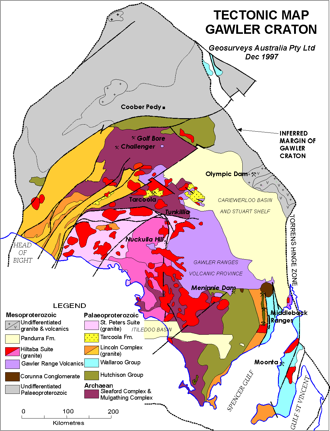
Datei:Tectonic Map of Grawler Craton.gif
Originaldatei (1.084 × 1.415 Pixel, Dateigröße: 70 KB, MIME-Typ: image/gif)

|
Dieses Bild des Typs Geology sollte als Vektorgrafik im SVG-Format neu erstellt werden. Vektorformate haben zahlreiche Vorteile; weitere Information unter Commons:Media for cleanup. Wenn dir eine SVG-Version dieses Bildes vorliegt, so lade diese bitte hoch. Nach dem Hochladen der Datei ist diese Vorlage auf der aktuellen Bildbeschreibungsseite durch die Vorlage {{Vector version available}}, oder kürzer {{Vva}}, zu ersetzen. Es ist empfohlen die neue SVG-Datei „Tectonic Map of Grawler Craton.svg“ zu nennen – dann benötigt die Vorlage vector version available (bzw. vva) keinen Parameter.
|
Beschreibung
| Beschreibung | Tectonic Map of Gawler Craton |
| Datum | |
| Quelle | http://www.users.on.net/~geosurveys/gawler3.htm Geosurveys Australia Pty Ltd |
| Urheber | Geosurveys Australia Pty Ltd |
| Genehmigung (Weiternutzung dieser Datei) |
"Please feel free to copy and use this brief review of the Gawler Craton and the following map generated by Geosurveys Australia Pty Ltd." |
Note
"The Gawler Craton is a Precambrian crystalline basement crustal block cratonised ca. 1550-1450 Ma. Prior to 1550 Ma the craton comprised a number of active Proterozoic orogenic belts extending back in time to at least 2450 Ma.
The Craton can be subdivided into a number of tectonic subdomains on the basis of structure and tectonostratigraphic history. Central Eyre Peninsula straddles the boundary between the Archaean to early Palaeoproterozoic Coulta Subdomain and the Cleve Subdomain, a Palaeoproterozoic orogenic belt ("mobile zone") probably representing a shelf or basinal depository for the Hutchison Group (ca. 1900-1845 Ma) prior to its deformation during the Kimban Orogeny (ca. 1845-1710 Ma). On northeastern Eyre Peninsula, the Cleve Subdomain is bounded by the slightly younger Moonta Subdomain which is characterised by less intensely deformed/metamorphosed acid volcanics and sediments ranging from the Myola Volcanics and Moonta Porphyry to the Moonabie Formation and Wandearah Metasiltstone.
On western Eyre Peninsula, the Coulta Subdomain merges with the Nuyts Subdomain which is dominated by variably deformed ca. 1670-1610 Ma granitoids, mafics and felsic volcanics. Deformation is attributed to the Kalaran Orogeny which generated a major fold belt or shear zone, the Fowler Shear Zone, ca. 1600-1540 Ma. In the central Craton, the Yarlbrinda Shear Zone was likely formed by the Kararan Orogeny and it is host to several major gold prospects including those in the Nuckulla Hill region (Sheoak, Myall and Bimba) and at Tunkillia (see adjacent aeromagnetic map).
Palaeoproterozoic rocks of the eastern and central Gawler Craton are overlain by relatively unmetamorphosed clastics of the Corunna Conglomerate, the Gawler Range Volcanics, the Pandurra Formation, and thin platformal late Proterozoic and Cambrian sediments of the Stuart and Spencer Shelves. In and around the Gawler Ranges, the volcanics and older rocks were intruded by Hiltaba Suite granites which are closely associated with formation of the giant Olympic Dam orebody. Although relatively undeformed, the Gawler Range Volcanics, which extend from the centre of the craton to its eastern margin, represent a major period of crustal deformation ca. 1590 Ma which heralded the final consolidation and stabilization of the craton as it is seen today.
Subsequent deformation on the craton has been largely epeirogenic forming shallow fault-bounded intracontinental depressions represented by Cainozoic basins, the southern continental margin and Spencer Gulf.
Please feel free to copy and use this brief review of the Gawler Craton and the following map generated by Geosurveys Australia Pty Ltd. For further detailed information on the Craton and other Proterozoic terrains in southern Australia contact either John Parker, Richard Flint or Robin Uppill. We would be pleased to discuss the geology and mineral potential of southern Australia with you or to conduct field workshops to show you some of the critical key outcrops."[1]
references
Lizenz

|
Der Urheberrechtsinhaber erlaubt es jedem, dieses Werk für jeglichen Zweck, inklusive uneingeschränkter Weiterveröffentlichung, kommerziellem Gebrauch und Modifizierung, zu nutzen.
Anmerkung: |
Dateiversionen
Klicke auf einen Zeitpunkt, um diese Version zu laden.
| Version vom | Vorschaubild | Maße | Benutzer | Kommentar | |
|---|---|---|---|---|---|
| aktuell | 18:03, 24. Jun. 2012 | | 1.084 × 1.415 (70 KB) | wikimediacommons>Dudy001 | complete image (hopefully) |
Dateiverwendung
Die folgende Seite verwendet diese Datei: